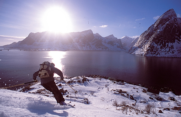
Far from classic destinations, the Lofoten Islands in northern Norway offer beautiful ski tours of moderate difficulty.
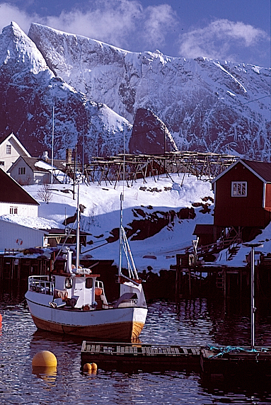
The Lofoten Islands are a group of islands located in Norway, north of the Arctic Circle, between latitudes 67 and 68. Known for its ‘climbing potential’ in summer, it’s a classic destination for Norwegian guide courses. In winter, it’s an archipelago perfectly suited for ski touring, offering a magical blend of imposing mountains, granite cliffs plunging into the sea, and picturesque fishing villages where cod dry in the open air.
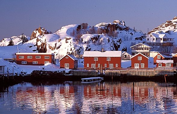
Our base camp: a fisherman’s cabin…
Svolvaer airport’s runway is covered in fresh snow, and we land in a cloud of powder with Wideroe’s local twin-engine 814 V. Shortly after, we arrive in the charming village of Kabelvag, where we search for our cabin or ‘rorbu,’ which will be our base camp for two weeks.
“The Four Currents”
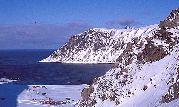
It is often said that ‘the four currents’ created the Lofoten Islands. The archipelago extends into the sea like a protrusion, forming a kind of outstretched arm north of the Norwegian coast. Even in the past, this rather special location attracted the attention of many navigators and appeared very early on numerous maps. With its large granite walls rising from the sea, these islands form a kind of rampart that catches everything that passes: wind, rain, storms, strong ocean currents, but also and above all, the magical ‘Gulf Stream.’ This warm current helps to warm the Lofoten Islands, resulting in higher temperatures than in Alaska or Greenland, despite being at the same latitudes. Thanks to ‘the four currents,’ the region is rich and prosperous: the ‘Gulf Stream’ comes from the south, large cod banks from the north, fishermen from the east and west, and the fish itself is exported worldwide.
Caribbean turquoise water and mountain atmosphere in Flakstadoya
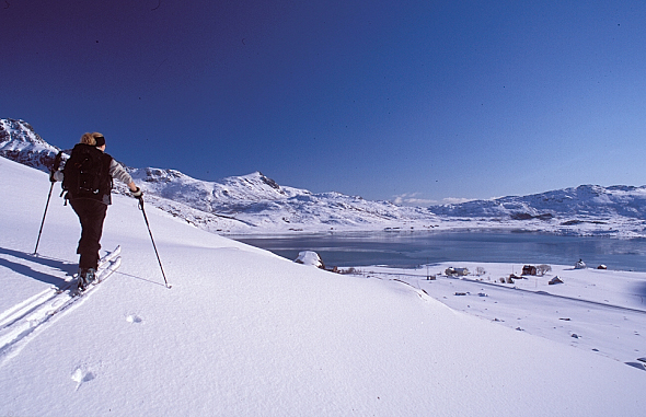
To begin our journey, we set out to explore the western coast to assess the ski touring potential of the archipelago. The single road (the E10) runs along the south coast for 160 kilometers, connecting Svolvaer to Å, the last village located at the far west. Bridges and tunnels connect the different islands, providing easy access to the entire archipelago.
Generally, ski touring departures are made from the road. For this first contact with Norwegian snow, we head to Flakstadoya. This village offers a contrasting spectacle: superb snow-dusted granite peaks like Stortinden (856 m) overlook Caribbean-style turquoise water bordered by fine sandy beaches. Here, familiar landmarks quickly disappear… From the hamlet of Bo (aptly named), where we attach our skins, a gentle slope leads to a pass near Moltinden, then to the summit of Flakstadtinden. The descent to Flakstad and its seaside beach is truly royal. In Rambert, a small neighboring village, we meet our first fishermen spreading their cod on large racks.
Meeting the Archipelago’s Only Mountain Guide
This evening, we toast warmly with Torbjörn, the only mountain guide based in the archipelago. He comes from Narvik and settled with his family in Henningsvear. He opened a guesthouse-bar, the Climbing-Café, as well as a mountaineering school. Over a good Norwegian beer, he explains the two weather regimes of the Lofoten Islands: ‘northern regime: good weather, cold, stable, and powder snow; southern regime: mild temperatures, bad weather, south wind, wet snow.’ In terms of avalanches, broadly speaking, it’s also quite binary: ‘northern regime: cold, stable snow; southern regime: warm and avalanche-prone.’ Clearly, with the Vikings, everything is very simple! Torbjörn also tells us that here, the weather can change abruptly 3 to 4 times a day – we had already noticed! – and that in winter, it can also rain for 7 consecutive days. His words make it clear that the weather here is definitely bad, and it’s best to plan at least two weeks minimum when coming for ski touring.
Kirstbergtinden: A Beautiful Pyramid
The next day, I pull back the curtain and glance out the window: rain and mixed snow… the usual! Two hours later, the sky clears a bit, and we head towards Vestpoltfjord. To its north, we discover a beautiful pyramid: Kirstbergtinden. The day before, I had spotted a faint trench in the alder zone that starts from the village of Vestpollen. The slope is steep for the first 300 meters; heavy snow, combined with an impenetrable jungle, prevents us from getting into a good rhythm. The weather has been gloomy since we left. When we arrive in the large cirque, below the summit, a black wall advances towards us, making us fear the worst. In a few minutes, we’re going to get hammered! We stop on the plateau to see how things will turn out. Ten minutes later, the snow arrives, flakes fall heavily, and the fog is very dense. We huddle in our Gore-Tex, waiting for it to pass. Half an hour later, the snowfall stops, leaving us in a thick fog. Nevertheless, we decide to continue on the south ridge, to the left of the large cirque. The initial slopes are quite steep until a more horizontal but narrower section. Progressing slowly on the ridge, we encounter a rocky step. We then swap our skis for crampons to climb these slabs covered in fresh snow. The rest is a succession of slabs and small gendarmes leading to the summit. The fog lifts a little upon our arrival at the final platform, and we even get a glimpse to the west, of Torskmannen.
The Lofoten Islands Delivered on Their Promises
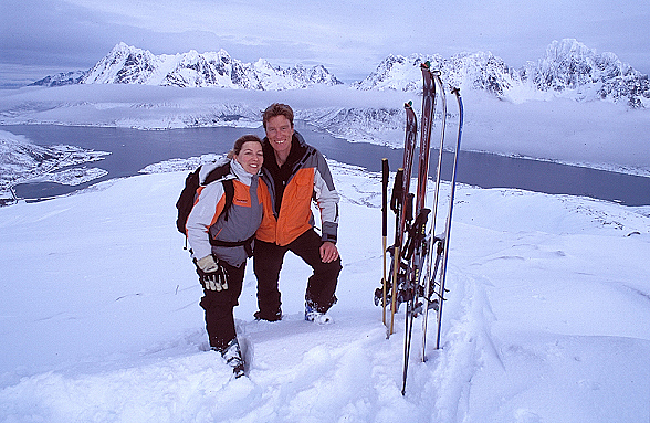
A few days later, the first fishermen leave the ‘rorbus’ of Kabelvag. South of Vestpolljfjord and its large lakes cutting the island of Austvogoya from east to west to Vatnfjord, lies a peak called Kvintinden. It’s a superb viewpoint in a very interesting region for ski touring: Austpollen and the Higravtinden range (1146 m), those of Geitgalen (1085 m), Lagstratinden (1158 m), and Rulten (1062 m), the highest peaks in the Lofoten Islands.
For now, Kvintinden is more suitable, given the rain and snow from last night. Step by step, we gain altitude, and the air cools. Under our skis, the snow improves; past the tree line, it’s drier and meringue-like on the surface: it seems to have been troweled onto the exposed granite pieces. As we reach the ridge extending to the summit, a few timid sunbeams pierce the clouds. Faces light up. The atmosphere is muffled, with wisps of clouds stretching along the fjord. We let our joy explode despite the polar temperature that greets us at the summit. Rulten, with its white shell, captivates our amazed gaze. Pale lights illuminate Vatnfjord below, while the sea appears all around us, 360 degrees. There’s no doubt, a land of snow and legends, the Lofoten Islands delivered on their promises during this winter exploration.
PRACTICAL INFORMATION
How to get there?
By plane: fly to Oslo then Bodo with Scandinavian Airlines (SAS). Five daily flights from Bodo to Svolvaer with SAS – Wideroe.
By boat: the Coastal Express, once a day between Bodo and Svolvaer.
Where to stay?
The right address:
“Climbing Café”
Thorbjorn Enevord
Nord Norsk Klatreskole
N – 8330 Henningsvear
email: postmaster@nordnorskklatreskole.no
Climate and Best Time to Visit
January and February are the coldest months, with an average temperature of –1°C; July and August are the warmest months with an average temperature of 12°C. The ideal period for ski touring is between March and May.
Maps, Guidebooks, Weather
There is no specific ski touring guidebook for the Lofoten Islands. As for maps, they are of very good quality in Norway. More information on the website of the geographical institute www.statkart.no and at the Svolvaer tourist office (tel: +47 76 07 30 00). For Austenfjord, get sheet 1131 I (Austvagoya). Norwegian weather in English: www.met.no/English. Avalanche bulletin: www.snoskred.no. Lofoten Tourist Office: www.lofoten.info.
Itineraries / Suggested Routes
Day trips of moderate difficulty, ideal for clients of intermediate level:
Geitgalen (1035 m): a kind of Norwegian Cerro Torre but very accessible via its north flank.
– Higravtinden (1140 m): this is the highest peak in the archipelago. Take a couloir on the northwest face. From the summit, several descent routes crisscross the face.
Trolltindan (987 m): isolated massif east of Geitgalen.
Trollfjord and Trollfjordtinden (830 m): Trollfjord is the most famous and most visited fjord in Norway. Its imposing walls attract tourist boats every summer who come to admire the beauty of the site. In winter, it is calm, and the place returns to its wild state.
Stauren (762 m) and Sauntinden (596 m) are located north of the village of Laupstad, at the end of Austenfjord.
Kirstbergtinden (660 m): a short, ideal route in unfavorable avalanche conditions.
Kvintinden (517 m): this modest peak is highly recommended on bad weather days.

